


 72 / 234

Ireland’s Environment – An Assessment 2016
68
Ireland’s Marine Environment
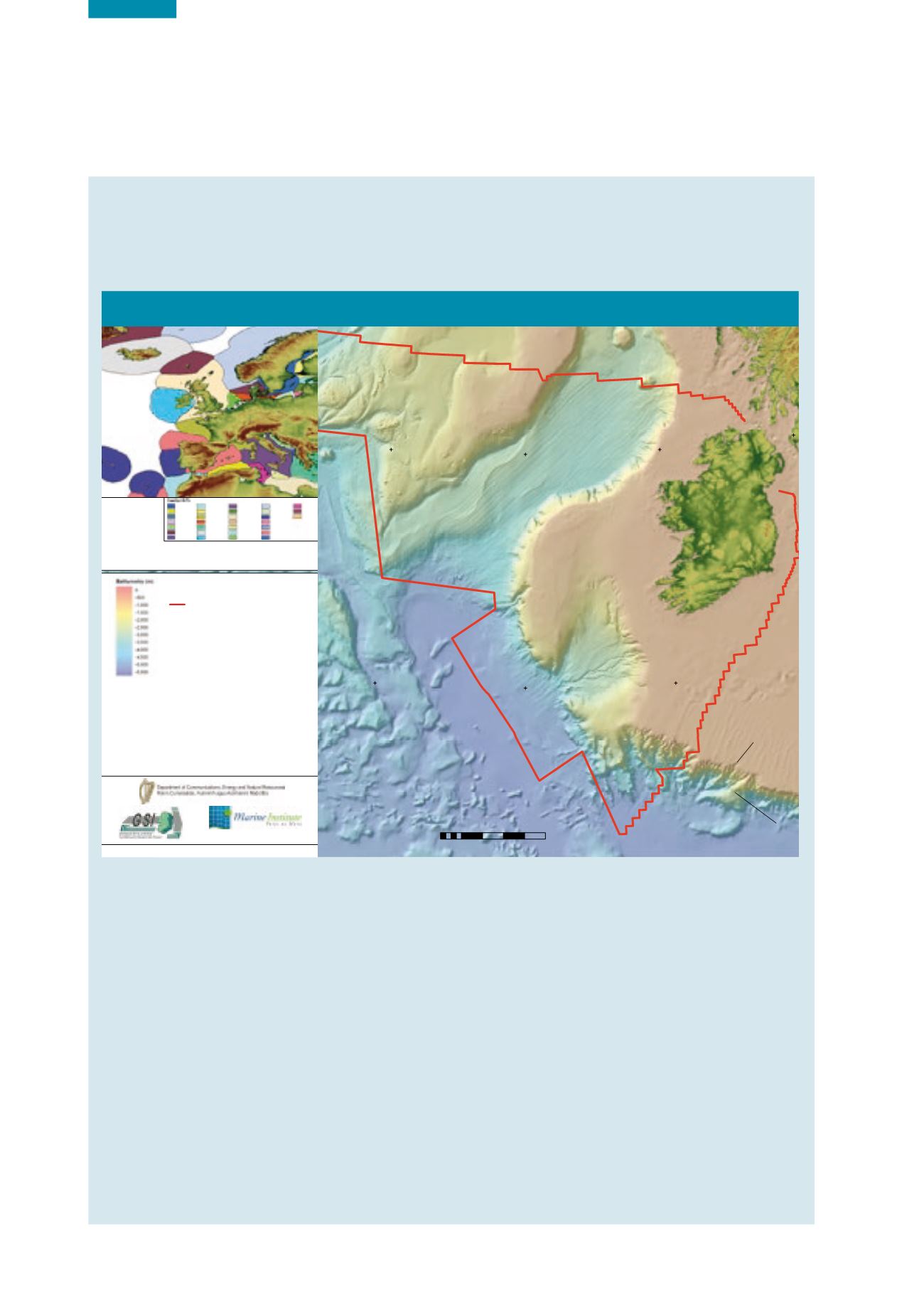
Ireland’s marine environment is one of the largest in the European Union (EU) and is nearly 10 times its land area.
The coastline is at the interface between the land and sea, with shallow estuaries that extend into the coastal zone
and out to the continental shelf to the west, which plunges to depths of over 4000 metres.
Figure 5.1
The Real Map of Ireland (Source: Marine Institute)
5°W
5°W
10°W
10°W
15°W
15°W
20°W
20°W
25°W
25°W
55°N
55°N
50°N
50°N
The Real Map of Ireland
0 50 100 150 200 250
25
Kilometers
²
Anton Dohrn
Seamount
Hebrides Terrace
Seamount
Porcupine
Seabight
Porcupine Abyssal Plain
Rockall
Bank
Feni Ridge
Edoras Bank
Maury Channel
Porcupine Bank
Celtic Shelf
Shamrock Canyon
Meriadzek Terrace
Goban Spur
Rockall Plateau
Rockall
Trough
MapCreated:April 2014
MapSpheroid:WGS-84
Map
Projection:UTM, Zone 28N
Bathymetry image derived from the following sources:PAD 1996, INSS2000-
2003,GEBCO 2003*.
Seabed feature names are derived fromGEBCOGazetteer ofUndersea
Features,available
fromwww.gebco.net.Consulted 2014 - 04 - 16.
Land elevation derived from theShuttleRadarTopographyMission 2000, led by
NGAandNASA.
THIS CHART IS NOT TO BE USED FOR NAVIGATION
*Reproduced from theGEBCODigitalAtlas published by theBritishOceanographicData
Centre on behalf of IOC and IHO, 2003.
The continental shelf is the extension of a states territorialwaterswhere the
natural prolongation of its land territory to the outer edge of the continental
margin is beyond 200 nauticalmiles from the coastal baseline.The coastal state
exercises over the continental shelf sovereign rights for the purpose of exploring
it and exploiting its natural resources, subject to the provisions ofPartVI of the
UnitedNationsConvention on the Law of theSea, available at
http://www.un.org/depts/los/convention_agreements/texts/unclos/part6.htm.Currently Designated
Irish Continental Shelf
www.marine.ieExclusiveEconomic
ZoneDivisions *
MapSpheroid:WGS-84
MapProjection:WGS-84
AnExclusiveEconomicZone (EEZ) is an area,notexceeding200nauticalmiles, inwhich coastal states have sovereign rightswith respect to
natural resources and certain economic activities, and exercise jurisdictionovermarine scientific research and environmental protection, subject
to theprovisions ofPartV of theUnitedNationsConvention on the Law of theSeawhich is available at
http://www.un.org/depts/los/convention_agreements/texts/unclos/part5.htm.Tunisia
Turkey
United
Kingdom
Albania
Algeria
Belgium
Bulgaria
Croatia
Denmark
Egypt
Estonia
Finland
France
Germany
Greece
Iceland
Ireland
Italy
Latvia
Libya
Lithuania
Malta
Morocco
Netherlands
Norway
Poland
Portugal
Russia
Montenegro
Spain
Sweden
*VLIZ (2012)MaritimeBoundariesGeodatabase,Version8.Availableonlineat
http://www.marineregions.org.Consultedon2014/04/16.
The IrishEEZ is inaccordancewith theMaritime Jurisdiction (Boundaries of theExclusiveEconomicZone)Order2014. Itwas provided by the
PetroleumAffairsDivision,Department forCommunications,Energy andNaturalResources,April 2014.
10°W
10°W
15°W
15°W
20°W
20°W
25°W
25°W
55°N
50°N
The Real Map of Ireland
0 50 100 150 200 250
25
Kilometers
²
Anton Dohrn
Seamount
Hebrides Terrace
Seamount
Porcupine
Seabight
Porcupine Abyssal Plain
Rockall
Bank
Feni Ridge
Edoras Bank
Maury Channel
Porcupine Bank
Celtic Shelf
Shamrock
Meri
Goban Spur
Rockall Plateau
Rockall
Trough
Map Created:April 2014
Map Spheroid: WGS-84
Map Projection: UTM, Zone 28 N
Bathymetry image derived from the following sources: PAD 1996, INSS 2000-
2003, GEBCO 2003*.
Seabed feature names are derived from GEBCO Gazetteer of Undersea
Features, available from
www.gebco.net.Consulted 2014 - 04 - 16.
Land elevation derived from the Shuttle RadarTopography Mission 2000, led by
NGAand NASA.
THIS CHART IS NOT TO BE USED FOR NAVIGATION
*Reproduced from theGEBCO DigitalAtl
as published by theBriti hOceanographicData
Centre on behalf of IOC and IHO, 2003.
The continental shelf is the extension of a states territorialwaterswhere the
natual pr longati n of its land territory to t
e outer edge of the continental
margin is beyond 200 nauticalmiles from the coastal baseline.The coastal state
exercises over the continental shelf sovereign rights for the purpose of exploring
it and exploiting its natural resources, subject to the provisions ofPartVI of the
UnitedNationsConvention on the Law of theSea, available at
http://www.un.org/depts/los/convention_agreements/texts/unclos/part6.htm.Currently Designated
Irish Continental Shelf
www.marine.ieExclusive Economic
Zone Divisions *
MapSpheroid:WGS-84
MapProjection:WGS-84
AnExclusiveEconomicZone (EEZ) is an area,notexceeding200nauticalmiles, inwhich coastal states have sovereign rightswith respect to
natural resources and certain economic activities, and exercise jurisdictionovermarine scientific research and environmental protection, subject
to theprovisions ofPartV of theUnitedNationsConvention on the Law of theSeawhich is available at
http://www.un.org/depts/los/convention_agreements/texts/unclos/part5.htm.Tunisia
Turkey
United
Kingdom
Albania
Algeria
Belgium
Bulgaria
Croatia
Denmark
Egypt
Estonia
Finland
France
Germany
Greece
Iceland
Ireland
Italy
Latvia
Libya
Lithuania
Malta
Morocco
Netherlands
Norway
Poland
Portugal
Russia
Montenegro
Spain
Sweden
*VLIZ (2012)MaritimeBoundariesGeodatabase,Version8.Availableonlineat
http://www.marineregions.org.Consultedon2014/04/16.
The IrishEEZ is inaccordancewith theMaritime Jurisdiction (Boundaries of theExclusiveEconomicZone)Order2014. Itwas provided by the
PetroleumAffairsDivision,Department forCommunications,Energy andNaturalResources,April 2014.
The temperate waters that surround Ireland are highly productive and provide a sustaining foundation for a rich mosaic
of marine life, including hundreds of species of invertebrates and fish, 24 species of whales and dolphins, breeding
colonies of both the common and grey seal and some of the largest breeding populations of seabirds in western Europe.
Ireland’s location in the Atlantic Ocean on the edge of the European continent has meant that, in comparison with
many other European countries, its marine environment has remained relatively unpolluted. In recent years, however,
the level of environmental stress, from both internal and external sources, has increased. Coastal development and
industrialisation, particularly during the 1990s, has resulted in an increase in the range and magnitude of pressures
that have the potential to impact negatively on the quality of Ireland’s tidal waters.
Pressures have also come from the intensification of agriculture and commercial fishing. The application of inorganic
fertilisers and changing farming practices have caused nutrient enrichment of inshore surface waters, and, in the
fishing sector, the use of new technologies and larger modern trawlers has allowed the capture of unsustainable
quantities of fish. The continued release of untreated sewage into the marine environment from several large towns
is a major cause of concern for coastal communities and ecosystems. In addition, the impacts of climate change pose
a significant and not yet fully understood threat to this environment.
In this chapter, the results from various monitoring programmes are used to assess the impact of human activities
on the tidal water environment (as well as the freshwater environment). The key pressures assessed include the
discharge of nutrients and other contaminants, dredging, marine litter, commercial fishing, aquaculture and the
effects of climate change. Information on these specific pressures and impacts is presented to provide an overview of
the general environmental status of estuarine, coastal and offshore waters around Ireland.